mozgi
GPT Image 2.0
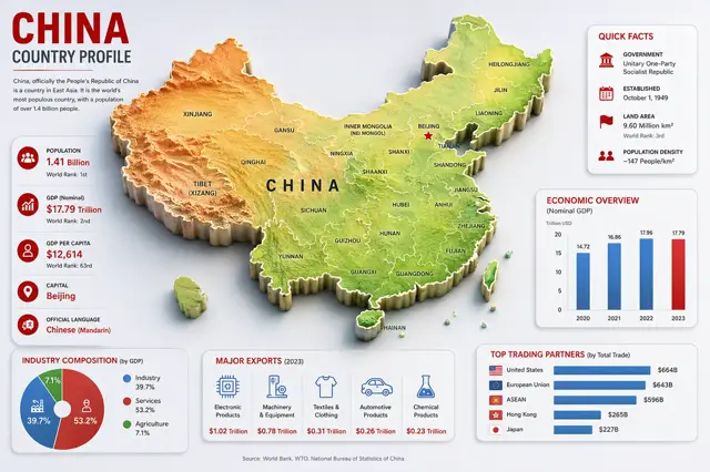
GPT Image 2.0 中具有 3D 地形圖和統計區塊的現代中國資訊圖表
提示詞
目標:建立一張乾淨、現代的中國國家概況資訊圖,標題為“CHINA COUNTRY PROFILE”,中央放置大型凸起的 3D 浮雕地圖,周圍配置統計卡片。

畫布:16:9 橫向資訊圖,淺灰色背景,清晰俐落的企業編輯風格,細緻陰影,紅/藍/綠點綴色,高解析度向量結合 3D 的視覺效果。

主地圖:在中央放置一張大型凸起的中國 3D 地形圖,佔據畫布大部分區域。使用地形配色:西部為橙棕色山地,中央為黃色高原,東部低地與海岸為綠色。加入白色省界與黑色省份標籤。將 Taiwan、Hainan 與南海小型島嶼以獨立的凸起區塊呈現。於中央放置大而字距寬鬆的黑色字母“CHINA”。以紅色星號標示 Beijing 並加上標籤。地圖上可見的標籤必須精確包含 28 個省/區/城市名稱:Xinjiang、Tibet (Xizang)、Qinghai、Gansu、Inner Mongolia (Nei Mongol)、Ningxia、Sichuan、Yunnan、Guizhou、Guangxi、Guangdong、Hainan、Fujian、Zhejiang、Jiangsu、Anhui、Shandong、Hubei、Hunan、Shaanxi、Shanxi、Beijing、Tianjin、Liaoning、Jilin、Heilongjiang、Taiwan,以及 China。

左上標題區塊:大型紅色標題“CHINA,”、深色副標題“COUNTRY PROFILE”、一條細紅色分隔線,以及一段簡短文字:“China, officially the People’s Republic of China is a country in East Asia. It is the world’s most populous country, with a population of over 1.4 billion people.”

左側統計卡片:一張高而圓角的白色卡片,包含恰好 5 列上下排列的事實資訊,每列都有紅色圓形圖示與文字。5 列為:人口 — 1.41 Billion — 世界排名:1st;國內生產毛額(名目)— $17.79 Trillion — 世界排名:2nd;平均每人國內生產毛額 — $12,614 — 世界排名:63rd;首都 — Beijing;官方語言 — Chinese (Mandarin)。列與列之間使用細分隔線。

右上快速資訊卡片:一張圓角白色卡片,標題為紅色“QUICK FACTS”。加入恰好 4 列並搭配紅色圖示:政府 — Unitary One-Party Socialist Republic;成立 — October 1, 1949;陸地面積 — 9.60 Million km²,世界排名:3rd;人口密度 — ~147 People/km²。

右中經濟圖表卡片:一張圓角白色卡片,標題為“ECONOMIC OVERVIEW”,副標題為“(Nominal GDP)”,並加上小型標籤“Trillion USD.”。加入 2020、2021、2022、2023 的恰好 4 根垂直長條,數值分別為 14.72、16.86、17.96、17.79。2020–2022 使用藍色長條,2023 使用紅色長條。

左下產業結構卡片:一張圓角白色卡片,標題為“INDUSTRY COMPOSITION (by GDP).”。加入恰好 3 個區段的甜甜圈圖:工業 39.7% 為藍色,服務業 53.2% 為紅色,農業 7.1% 為綠色。加入相符的圖例,使用相同的 3 個標籤與百分比。

下方中央出口卡片:一張圓角白色卡片,標題為“MAJOR EXPORTS (2023).”。加入恰好 5 個出口欄目,搭配藍色線條圖示與紅色數值:電子產品 — $1.02 Trillion;機械與設備 — $0.78 Trillion;紡織品與服裝 — $0.31 Trillion;汽車產品 — $0.26 Trillion;化學產品 — $0.23 Trillion。

右下貿易夥伴卡片:一張圓角白色卡片,標題為“TOP TRADING PARTNERS (by Total Trade).”。加入恰好 5 根水平藍色長條,搭配小型旗幟圖示與數值:United States — $664B;European Union — $643B;ASEAN — $596B;Hong Kong — $265B;Japan — $227B。

頁尾:在中央放置一行小型來源文字:“Source: World Bank, WTO, National Bureau of Statistics of China.”

限制:將所有卡片對齊配置於地圖周圍,且不得與地圖重疊;使用一致的字體排版、紅色標題、藍色圖表元素、細緻投影與圓角卡片;不得加入浮水印。
Goal: Create a clean, modern country-profile infographic for China, titled “CHINA COUNTRY PROFILE,” with a large central 3D raised relief map and surrounding statistical cards.

Canvas: 16:9 horizontal infographic, light gray background, crisp corporate editorial style, subtle shadows, red/blue/green accent colors, high-resolution vector-meets-3D look.

Main map: Place a large raised 3D topographic map of China in the center, occupying most of the canvas. Use terrain coloring: orange-brown mountains in the west, yellow central plateau, green eastern lowlands and coast. Add white province borders and black province labels. Include Taiwan, Hainan, and small South China Sea islands as separate raised pieces. Put large spaced black letters “CHINA” across the center. Mark Beijing with a red star and label it. Visible map labels should include exactly 28 province/region/city labels: Xinjiang, Tibet (Xizang), Qinghai, Gansu, Inner Mongolia (Nei Mongol), Ningxia, Sichuan, Yunnan, Guizhou, Guangxi, Guangdong, Hainan, Fujian, Zhejiang, Jiangsu, Anhui, Shandong, Hubei, Hunan, Shaanxi, Shanxi, Beijing, Tianjin, Liaoning, Jilin, Heilongjiang, Taiwan, and China.

Top-left title block: Big red headline “CHINA,” dark subtitle “COUNTRY PROFILE,” a thin red divider line, and a short paragraph: “China, officially the People’s Republic of China is a country in East Asia. It is the world’s most populous country, with a population of over 1.4 billion people.”

Left statistics card: A tall rounded white card with exactly 5 stacked fact rows, each with a red circular icon and text. The 5 rows are: Population — 1.41 Billion — World Rank: 1st; GDP (Nominal) — $17.79 Trillion — World Rank: 2nd; GDP Per Capita — $12,614 — World Rank: 63rd; Capital — Beijing; Official Language — Chinese (Mandarin). Use thin separators between rows.

Top-right quick facts card: A rounded white card titled “QUICK FACTS” in red. Include exactly 4 rows with red icons: Government — Unitary One-Party Socialist Republic; Established — October 1, 1949; Land Area — 9.60 Million km², World Rank: 3rd; Population Density — ~147 People/km².

Middle-right economic chart card: A rounded white card titled “ECONOMIC OVERVIEW” with subtitle “(Nominal GDP)” and small label “Trillion USD.” Include exactly 4 vertical bars for 2020, 2021, 2022, 2023 with values 14.72, 16.86, 17.96, 17.79. Use blue bars for 2020–2022 and a red bar for 2023.

Bottom-left industry card: A rounded white card titled “INDUSTRY COMPOSITION (by GDP).” Include exactly 3-part donut chart segments: Industry 39.7% in blue, Services 53.2% in red, Agriculture 7.1% in green. Add matching legend with the same 3 labels and percentages.

Bottom-center exports card: A rounded white card titled “MAJOR EXPORTS (2023).” Include exactly 5 export columns with blue line icons and red values: Electronic Products — $1.02 Trillion; Machinery & Equipment — $0.78 Trillion; Textiles & Clothing — $0.31 Trillion; Automotive Products — $0.26 Trillion; Chemical Products — $0.23 Trillion.

Bottom-right trading partners card: A rounded white card titled “TOP TRADING PARTNERS (by Total Trade).” Include exactly 5 horizontal blue bars with small flag icons and values: United States — $664B; European Union — $643B; ASEAN — $596B; Hong Kong — $265B; Japan — $227B.

Footer: Center a small source line reading “Source: World Bank, WTO, National Bureau of Statistics of China.”

Constraints: Keep all cards aligned around the map without overlapping it, use consistent typography, red headings, blue chart elements, subtle drop shadows, rounded card corners, and no watermark.
此提示詞的權利屬於作者 @abs_uiux。任何商業使用(推廣 AI 工具、聚合平台、Telegram 機器人)由你自行負責,mozgi.io 不承擔任何責任。 詳情 →